|
|
|||||||||||||||||
| Point ID: 547 | Downloads | Plots | Site Data | Code: 05FC004 |
|
|
|||||||||||||||||
| Download | |
|---|---|
| Site Descriptor Information | Site Time Series Data |
| Link to all available data | |
| View: | Time Series | All |
| Units: | mm |
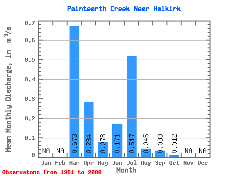
| Statistic | Jan | Feb | Mar | Apr | May | Jun | Jul | Aug | Sep | Oct | Nov | Dec | Annual |
|---|---|---|---|---|---|---|---|---|---|---|---|---|---|
| Mean | 0.67 | 0.28 | 0.08 | 0.17 | 0.52 | 0.04 | 0.03 | 0.01 | |||||
| Standard Deviation | 0.75 | 0.33 | 0.18 | 0.33 | 0.80 | 0.10 | 0.11 | 0.04 | |||||
| Min | 0.00 | 0.01 | 0.00 | 0.00 | 0.00 | 0.00 | 0.00 | 0.00 | |||||
| Max | 2.19 | 0.97 | 0.69 | 1.19 | 2.18 | 0.36 | 0.47 | 0.17 | |||||
| Coefficient of Variation | 1.12 | 1.15 | 2.27 | 1.95 | 1.54 | 2.15 | 3.20 | 3.15 |
 Return to R-Arctic Net Home Page