|
|
|||||||||||||||||
| Point ID: 547 | Downloads | Plots | Site Data | Code: 05FC004 |
|
|
|||||||||||||||||
| Download | |
|---|---|
| Site Descriptor Information | Site Time Series Data |
| Link to all available data | |
| View: | Time Series | All |
| Units: | m3/s |
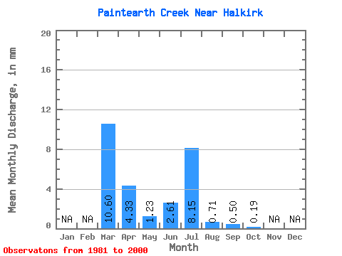
| Statistic | Jan | Feb | Mar | Apr | May | Jun | Jul | Aug | Sep | Oct | Nov | Dec | Annual |
|---|---|---|---|---|---|---|---|---|---|---|---|---|---|
| Mean | 9.48 | 3.88 | 1.10 | 2.33 | 7.28 | 0.63 | 0.46 | 0.17 | |||||
| Standard Deviation | 10.61 | 4.45 | 2.50 | 4.54 | 11.20 | 1.36 | 1.46 | 0.55 | |||||
| Min | 0.06 | 0.07 | 0.00 | 0.00 | 0.00 | 0.00 | 0.00 | 0.00 | |||||
| Max | 30.87 | 13.19 | 9.72 | 16.23 | 30.73 | 5.02 | 6.38 | 2.45 | |||||
| Coefficient of Variation | 1.12 | 1.15 | 2.27 | 1.95 | 1.54 | 2.15 | 3.20 | 3.15 |
 Return to R-Arctic Net Home Page