|
|
|||||||||||||||||
| Point ID: 5469 | Downloads | Plots | Site Data | Code: 05LB003 |
|
|
|||||||||||||||||
| Download | |
|---|---|
| Site Descriptor Information | Site Time Series Data |
| Link to all available data | |
| View: | Time Series | All |
| Units: | mm |
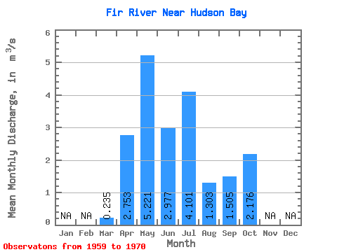
| Statistic | Jan | Feb | Mar | Apr | May | Jun | Jul | Aug | Sep | Oct | Nov | Dec | Annual |
|---|---|---|---|---|---|---|---|---|---|---|---|---|---|
| Mean | 0.23 | 2.75 | 5.22 | 2.98 | 4.10 | 1.30 | 1.50 | 2.18 | |||||
| Standard Deviation | 0.30 | 1.79 | 2.95 | 2.97 | 3.88 | 0.71 | 0.93 | 0.65 | |||||
| Min | 0.00 | 0.00 | 0.94 | 0.41 | 0.01 | 0.66 | 0.26 | 1.53 | |||||
| Max | 0.76 | 6.13 | 9.24 | 8.55 | 8.61 | 2.35 | 2.50 | 2.99 | |||||
| Coefficient of Variation | 1.29 | 0.65 | 0.57 | 1.00 | 0.95 | 0.54 | 0.62 | 0.30 |
 Return to R-Arctic Net Home Page