|
|
|||||||||||||||||
| Point ID: 5469 | Downloads | Plots | Site Data | Code: 05LB003 |
|
|
|||||||||||||||||
| Download | |
|---|---|
| Site Descriptor Information | Site Time Series Data |
| Link to all available data | |
| View: | Time Series | All |
| Units: | m3/s |
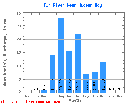
| Statistic | Jan | Feb | Mar | Apr | May | Jun | Jul | Aug | Sep | Oct | Nov | Dec | Annual |
|---|---|---|---|---|---|---|---|---|---|---|---|---|---|
| Mean | 1.26 | 14.27 | 27.96 | 15.43 | 21.96 | 6.98 | 7.80 | 11.65 | |||||
| Standard Deviation | 1.63 | 9.28 | 15.82 | 15.41 | 20.77 | 3.79 | 4.84 | 3.50 | |||||
| Min | 0.00 | 0.00 | 5.04 | 2.13 | 0.03 | 3.51 | 1.36 | 8.20 | |||||
| Max | 4.07 | 31.78 | 49.49 | 44.32 | 46.12 | 12.59 | 12.96 | 16.01 | |||||
| Coefficient of Variation | 1.29 | 0.65 | 0.57 | 1.00 | 0.95 | 0.54 | 0.62 | 0.30 |
 Return to R-Arctic Net Home Page