|
|
|||||||||||||||||
| Point ID: 5467 | Downloads | Plots | Site Data | Code: 05LB001 |
|
|
|||||||||||||||||
| Download | |
|---|---|
| Site Descriptor Information | Site Time Series Data |
| Link to all available data | |
| View: | Time Series | All |
| Units: | mm |
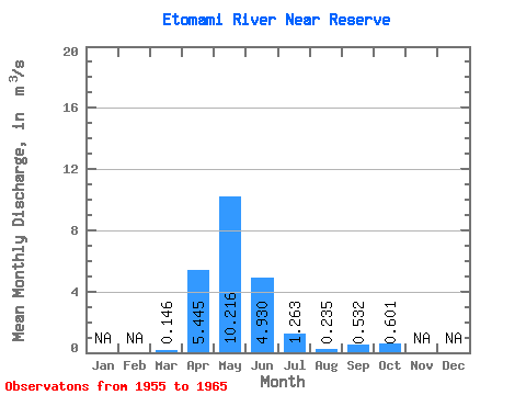
| Statistic | Jan | Feb | Mar | Apr | May | Jun | Jul | Aug | Sep | Oct | Nov | Dec | Annual |
|---|---|---|---|---|---|---|---|---|---|---|---|---|---|
| Mean | 0.15 | 5.45 | 10.22 | 4.93 | 1.26 | 0.23 | 0.53 | 0.60 | |||||
| Standard Deviation | 0.19 | 5.75 | 10.32 | 8.60 | 1.90 | 0.18 | 0.65 | 0.94 | |||||
| Min | 0.00 | 0.58 | 0.73 | 0.12 | 0.00 | 0.00 | 0.00 | 0.01 | |||||
| Max | 0.67 | 20.60 | 31.00 | 29.50 | 6.42 | 0.57 | 2.03 | 3.25 | |||||
| Coefficient of Variation | 1.32 | 1.05 | 1.01 | 1.74 | 1.51 | 0.79 | 1.22 | 1.57 |
 Return to R-Arctic Net Home Page