|
|
|||||||||||||||||
| Point ID: 5467 | Downloads | Plots | Site Data | Code: 05LB001 |
|
|
|||||||||||||||||
| Download | |
|---|---|
| Site Descriptor Information | Site Time Series Data |
| Link to all available data | |
| View: | Time Series | All |
| Units: | m3/s |
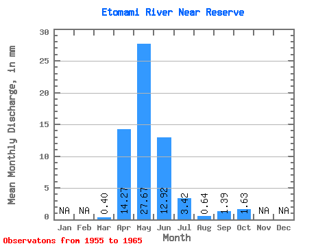
| Statistic | Jan | Feb | Mar | Apr | May | Jun | Jul | Aug | Sep | Oct | Nov | Dec | Annual |
|---|---|---|---|---|---|---|---|---|---|---|---|---|---|
| Mean | 0.35 | 12.83 | 24.87 | 11.62 | 3.08 | 0.57 | 1.25 | 1.46 | |||||
| Standard Deviation | 0.47 | 13.54 | 25.14 | 20.26 | 4.64 | 0.45 | 1.53 | 2.29 | |||||
| Min | 0.00 | 1.36 | 1.77 | 0.28 | 0.01 | 0.01 | 0.01 | 0.01 | |||||
| Max | 1.62 | 48.54 | 75.47 | 69.51 | 15.63 | 1.40 | 4.78 | 7.91 | |||||
| Coefficient of Variation | 1.32 | 1.05 | 1.01 | 1.74 | 1.51 | 0.79 | 1.22 | 1.57 |
 Return to R-Arctic Net Home Page