|
|
|||||||||||||||||
| Point ID: 544 | Downloads | Plots | Site Data | Code: 05FC001 |
|
|
|||||||||||||||||
| Download | |
|---|---|
| Site Descriptor Information | Site Time Series Data |
| Link to all available data | |
| View: | Time Series | All |
| Units: | mm |
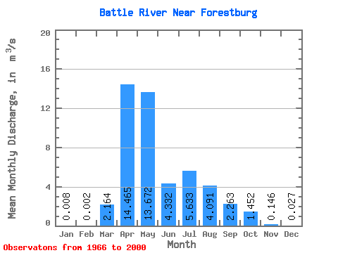
| Statistic | Jan | Feb | Mar | Apr | May | Jun | Jul | Aug | Sep | Oct | Nov | Dec | Annual |
|---|---|---|---|---|---|---|---|---|---|---|---|---|---|
| Mean | 0.01 | 0.00 | 2.16 | 14.46 | 13.67 | 4.33 | 5.63 | 4.09 | 2.26 | 1.45 | 0.15 | 0.03 | |
| Standard Deviation | 3.32 | 10.92 | 23.50 | 5.45 | 8.62 | 5.26 | 2.48 | 1.77 | |||||
| Min | 0.01 | 0.00 | 0.00 | 0.90 | 0.55 | 0.06 | 0.08 | 0.01 | 0.02 | 0.01 | 0.15 | 0.03 | |
| Max | 0.01 | 0.00 | 15.50 | 52.10 | 137.00 | 31.60 | 36.00 | 20.00 | 7.94 | 8.47 | 0.15 | 0.03 | |
| Coefficient of Variation | 1.53 | 0.76 | 1.72 | 1.26 | 1.53 | 1.29 | 1.10 | 1.22 |
 Return to R-Arctic Net Home Page