|
|
|||||||||||||||||
| Point ID: 544 | Downloads | Plots | Site Data | Code: 05FC001 |
|
|
|||||||||||||||||
| Download | |
|---|---|
| Site Descriptor Information | Site Time Series Data |
| Link to all available data | |
| View: | Time Series | All |
| Units: | m3/s |
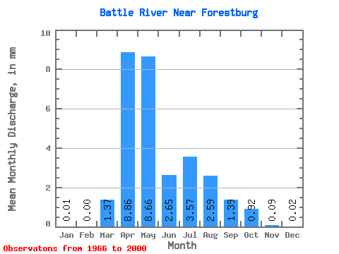
| Statistic | Jan | Feb | Mar | Apr | May | Jun | Jul | Aug | Sep | Oct | Nov | Dec | Annual |
|---|---|---|---|---|---|---|---|---|---|---|---|---|---|
| Mean | 0.00 | 0.00 | 0.76 | 4.88 | 4.77 | 1.46 | 1.96 | 1.43 | 0.76 | 0.51 | 0.05 | 0.01 | |
| Standard Deviation | 1.16 | 3.69 | 8.19 | 1.84 | 3.01 | 1.83 | 0.84 | 0.62 | |||||
| Min | 0.00 | 0.00 | 0.00 | 0.30 | 0.19 | 0.02 | 0.03 | 0.00 | 0.01 | 0.00 | 0.05 | 0.01 | |
| Max | 0.00 | 0.00 | 5.41 | 17.58 | 47.77 | 10.66 | 12.55 | 6.97 | 2.68 | 2.95 | 0.05 | 0.01 | |
| Coefficient of Variation | 1.53 | 0.76 | 1.72 | 1.26 | 1.53 | 1.29 | 1.10 | 1.22 |
 Return to R-Arctic Net Home Page