|
|
|||||||||||||||||
| Point ID: 5438 | Downloads | Plots | Site Data | Code: 05KC002 |
|
|
|||||||||||||||||
| Download | |
|---|---|
| Site Descriptor Information | Site Time Series Data |
| Link to all available data | |
| View: | Time Series | All |
| Units: | mm |
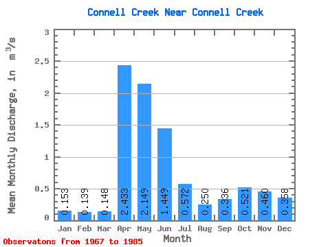
| Statistic | Jan | Feb | Mar | Apr | May | Jun | Jul | Aug | Sep | Oct | Nov | Dec | Annual |
|---|---|---|---|---|---|---|---|---|---|---|---|---|---|
| Mean | 0.15 | 0.14 | 0.15 | 2.43 | 2.15 | 1.45 | 0.57 | 0.25 | 0.34 | 0.52 | 0.46 | 0.36 | |
| Standard Deviation | 0.09 | 1.34 | 1.95 | 1.29 | 0.68 | 0.12 | 0.21 | 0.26 | |||||
| Min | 0.15 | 0.14 | 0.00 | 0.75 | 0.24 | 0.17 | 0.10 | 0.10 | 0.11 | 0.20 | 0.46 | 0.36 | |
| Max | 0.15 | 0.14 | 0.28 | 4.37 | 6.61 | 4.12 | 2.52 | 0.55 | 0.84 | 1.12 | 0.46 | 0.36 | |
| Coefficient of Variation | 0.57 | 0.55 | 0.91 | 0.89 | 1.20 | 0.50 | 0.62 | 0.51 |
 Return to R-Arctic Net Home Page