|
|
|||||||||||||||||
| Point ID: 5438 | Downloads | Plots | Site Data | Code: 05KC002 |
|
|
|||||||||||||||||
| Download | |
|---|---|
| Site Descriptor Information | Site Time Series Data |
| Link to all available data | |
| View: | Time Series | All |
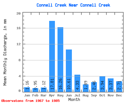
| Units: | m3/s |
| Statistic | Jan | Feb | Mar | Apr | May | Jun | Jul | Aug | Sep | Oct | Nov | Dec | Annual |
|---|---|---|---|---|---|---|---|---|---|---|---|---|---|
| Mean | 1.16 | 0.96 | 1.12 | 17.81 | 16.26 | 10.61 | 4.32 | 1.89 | 2.46 | 3.94 | 3.37 | 2.71 | |
| Standard Deviation | 0.64 | 9.82 | 14.77 | 9.48 | 5.17 | 0.94 | 1.54 | 1.99 | |||||
| Min | 1.16 | 0.96 | 0.00 | 5.48 | 1.85 | 1.27 | 0.73 | 0.79 | 0.78 | 1.52 | 3.37 | 2.71 | |
| Max | 1.16 | 0.96 | 2.10 | 32.00 | 50.00 | 30.17 | 19.06 | 4.15 | 6.19 | 8.47 | 3.37 | 2.71 | |
| Coefficient of Variation | 0.57 | 0.55 | 0.91 | 0.89 | 1.20 | 0.50 | 0.62 | 0.51 |
 Return to R-Arctic Net Home Page