|
|
|||||||||||||||||
| Point ID: 5408 | Downloads | Plots | Site Data | Code: 05JM003 |
|
|
|||||||||||||||||
| Download | |
|---|---|
| Site Descriptor Information | Site Time Series Data |
| Link to all available data | |
| View: | Time Series | All |
| Units: | mm |
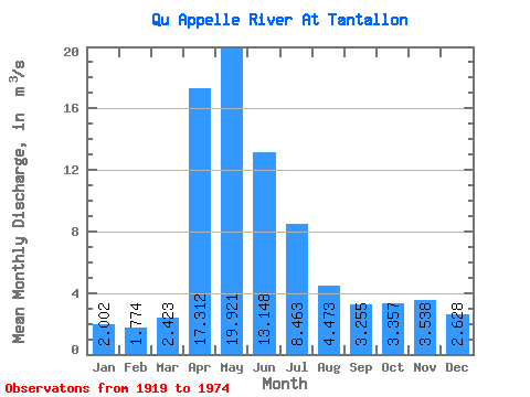
| Statistic | Jan | Feb | Mar | Apr | May | Jun | Jul | Aug | Sep | Oct | Nov | Dec | Annual |
|---|---|---|---|---|---|---|---|---|---|---|---|---|---|
| Mean | 2.00 | 1.77 | 2.42 | 17.31 | 19.92 | 13.15 | 8.46 | 4.47 | 3.25 | 3.36 | 3.54 | 2.63 | 7.73 |
| Standard Deviation | 2.62 | 2.26 | 2.67 | 16.10 | 26.12 | 15.73 | 13.54 | 8.31 | 5.93 | 5.55 | 4.81 | 3.38 | 9.53 |
| Min | 0.00 | 0.00 | 0.00 | 0.90 | 0.43 | 0.28 | 0.02 | 0.00 | 0.00 | 0.00 | 0.00 | 0.00 | 0.19 |
| Max | 8.15 | 7.64 | 8.96 | 67.50 | 135.00 | 65.00 | 65.80 | 36.60 | 26.80 | 22.30 | 16.50 | 11.40 | 37.30 |
| Coefficient of Variation | 1.31 | 1.27 | 1.10 | 0.93 | 1.31 | 1.20 | 1.60 | 1.86 | 1.82 | 1.65 | 1.36 | 1.28 | 1.23 |
 Return to R-Arctic Net Home Page