|
|
|||||||||||||||||
| Point ID: 5408 | Downloads | Plots | Site Data | Code: 05JM003 |
|
|
|||||||||||||||||
| Download | |
|---|---|
| Site Descriptor Information | Site Time Series Data |
| Link to all available data | |
| View: | Time Series | All |
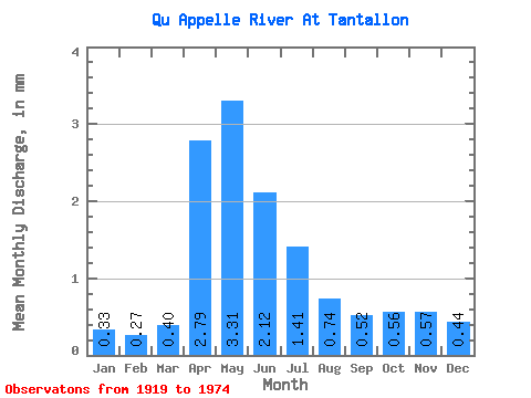
| Units: | m3/s |
| Statistic | Jan | Feb | Mar | Apr | May | Jun | Jul | Aug | Sep | Oct | Nov | Dec | Annual |
|---|---|---|---|---|---|---|---|---|---|---|---|---|---|
| Mean | 0.11 | 0.09 | 0.13 | 0.91 | 1.08 | 0.69 | 0.46 | 0.24 | 0.17 | 0.18 | 0.19 | 0.14 | 4.96 |
| Standard Deviation | 0.14 | 0.11 | 0.14 | 0.85 | 1.42 | 0.83 | 0.74 | 0.45 | 0.31 | 0.30 | 0.25 | 0.18 | 6.11 |
| Min | 0.00 | 0.00 | 0.00 | 0.05 | 0.02 | 0.01 | 0.00 | 0.00 | 0.00 | 0.00 | 0.00 | 0.00 | 0.12 |
| Max | 0.44 | 0.38 | 0.49 | 3.56 | 7.35 | 3.42 | 3.58 | 1.99 | 1.41 | 1.21 | 0.87 | 0.62 | 23.93 |
| Coefficient of Variation | 1.31 | 1.27 | 1.10 | 0.93 | 1.31 | 1.20 | 1.60 | 1.86 | 1.82 | 1.65 | 1.36 | 1.28 | 1.23 |
 Return to R-Arctic Net Home Page