|
|
|||||||||||||||||
| Point ID: 5364 | Downloads | Plots | Site Data | Code: 05JF001 |
|
|
|||||||||||||||||
| Download | |
|---|---|
| Site Descriptor Information | Site Time Series Data |
| Link to all available data | |
| View: | Time Series | All |
| Units: | mm |
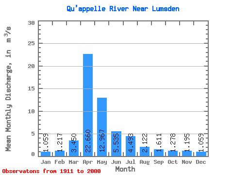
| Statistic | Jan | Feb | Mar | Apr | May | Jun | Jul | Aug | Sep | Oct | Nov | Dec | Annual |
|---|---|---|---|---|---|---|---|---|---|---|---|---|---|
| Mean | 1.06 | 1.22 | 3.45 | 22.66 | 12.97 | 5.54 | 4.49 | 2.12 | 1.61 | 1.28 | 1.20 | 1.06 | 5.82 |
| Standard Deviation | 0.95 | 1.34 | 5.81 | 29.21 | 17.96 | 5.84 | 5.77 | 2.45 | 1.56 | 1.14 | 0.74 | 0.80 | 4.62 |
| Min | 0.00 | 0.00 | 0.00 | 0.25 | 0.32 | 0.22 | 0.12 | 0.02 | 0.04 | 0.09 | 0.06 | 0.02 | 0.13 |
| Max | 5.04 | 6.45 | 43.70 | 127.00 | 94.80 | 25.30 | 29.60 | 15.30 | 7.87 | 4.90 | 4.07 | 4.08 | 21.91 |
| Coefficient of Variation | 0.90 | 1.10 | 1.68 | 1.29 | 1.39 | 1.05 | 1.28 | 1.15 | 0.97 | 0.89 | 0.62 | 0.75 | 0.79 |
 Return to R-Arctic Net Home Page