|
|
|||||||||||||||||
| Point ID: 5361 | Downloads | Plots | Site Data | Code: 05JE006 |
|
|
|||||||||||||||||
| Download | |
|---|---|
| Site Descriptor Information | Site Time Series Data |
| Link to all available data | |
| View: | Time Series | All |
| Units: | mm |
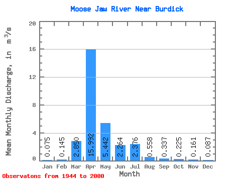
| Statistic | Jan | Feb | Mar | Apr | May | Jun | Jul | Aug | Sep | Oct | Nov | Dec | Annual |
|---|---|---|---|---|---|---|---|---|---|---|---|---|---|
| Mean | 0.07 | 0.14 | 2.85 | 15.99 | 5.44 | 2.26 | 2.38 | 0.56 | 0.34 | 0.23 | 0.16 | 0.09 | 2.64 |
| Standard Deviation | 0.07 | 0.16 | 6.66 | 22.14 | 10.50 | 6.91 | 4.42 | 1.28 | 1.03 | 0.53 | 0.15 | 0.06 | 3.28 |
| Min | 0.00 | 0.00 | 0.00 | 0.00 | 0.00 | 0.00 | 0.00 | 0.00 | 0.00 | 0.00 | 0.00 | 0.00 | 0.00 |
| Max | 0.22 | 0.80 | 42.90 | 91.00 | 46.20 | 49.10 | 20.80 | 7.69 | 7.06 | 3.59 | 0.67 | 0.26 | 11.82 |
| Coefficient of Variation | 0.91 | 1.11 | 2.33 | 1.39 | 1.93 | 3.05 | 1.86 | 2.30 | 3.06 | 2.35 | 0.92 | 0.74 | 1.24 |
 Return to R-Arctic Net Home Page