|
|
|||||||||||||||||
| Point ID: 5361 | Downloads | Plots | Site Data | Code: 05JE006 |
|
|
|||||||||||||||||
| Download | |
|---|---|
| Site Descriptor Information | Site Time Series Data |
| Link to all available data | |
| View: | Time Series | All |
| Units: | m3/s |
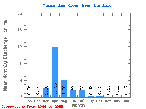
| Statistic | Jan | Feb | Mar | Apr | May | Jun | Jul | Aug | Sep | Oct | Nov | Dec | Annual |
|---|---|---|---|---|---|---|---|---|---|---|---|---|---|
| Mean | 0.02 | 0.04 | 0.83 | 4.49 | 1.58 | 0.64 | 0.69 | 0.16 | 0.10 | 0.07 | 0.04 | 0.03 | 9.04 |
| Standard Deviation | 0.02 | 0.04 | 1.93 | 6.22 | 3.05 | 1.94 | 1.28 | 0.37 | 0.29 | 0.15 | 0.04 | 0.02 | 11.22 |
| Min | 0.00 | 0.00 | 0.00 | 0.00 | 0.00 | 0.00 | 0.00 | 0.00 | 0.00 | 0.00 | 0.00 | 0.00 | 0.01 |
| Max | 0.06 | 0.21 | 12.45 | 25.55 | 13.40 | 13.79 | 6.04 | 2.23 | 1.98 | 1.04 | 0.19 | 0.07 | 40.42 |
| Coefficient of Variation | 0.91 | 1.11 | 2.33 | 1.39 | 1.93 | 3.05 | 1.86 | 2.30 | 3.06 | 2.35 | 0.92 | 0.74 | 1.24 |
 Return to R-Arctic Net Home Page