|
|
|||||||||||||||||
| Point ID: 5357 | Downloads | Plots | Site Data | Code: 05JE002 |
|
|
|||||||||||||||||
| Download | |
|---|---|
| Site Descriptor Information | Site Time Series Data |
| Link to all available data | |
| View: | Time Series | All |
| Units: | mm |
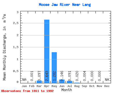
| Statistic | Jan | Feb | Mar | Apr | May | Jun | Jul | Aug | Sep | Oct | Nov | Dec | Annual |
|---|---|---|---|---|---|---|---|---|---|---|---|---|---|
| Mean | 0.00 | 0.10 | 2.64 | 1.28 | 0.15 | 0.09 | 0.02 | 0.00 | 0.00 | 0.00 | |||
| Standard Deviation | 0.23 | 4.22 | 2.85 | 0.29 | 0.29 | 0.06 | 0.01 | 0.00 | |||||
| Min | 0.00 | 0.00 | 0.00 | 0.00 | 0.00 | 0.00 | 0.00 | 0.00 | 0.00 | 0.00 | |||
| Max | 0.00 | 0.88 | 17.60 | 11.90 | 0.96 | 1.28 | 0.27 | 0.07 | 0.01 | 0.00 | |||
| Coefficient of Variation | 2.42 | 1.60 | 2.23 | 2.00 | 3.21 | 3.01 | 3.47 | 5.66 |
 Return to R-Arctic Net Home Page