|
|
|||||||||||||||||
| Point ID: 5357 | Downloads | Plots | Site Data | Code: 05JE002 |
|
|
|||||||||||||||||
| Download | |
|---|---|
| Site Descriptor Information | Site Time Series Data |
| Link to all available data | |
| View: | Time Series | All |
| Units: | m3/s |
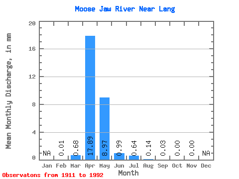
| Statistic | Jan | Feb | Mar | Apr | May | Jun | Jul | Aug | Sep | Oct | Nov | Dec | Annual |
|---|---|---|---|---|---|---|---|---|---|---|---|---|---|
| Mean | 0.00 | 0.30 | 7.83 | 3.92 | 0.43 | 0.28 | 0.06 | 0.01 | 0.00 | 0.00 | |||
| Standard Deviation | 0.72 | 12.51 | 8.73 | 0.86 | 0.90 | 0.19 | 0.04 | 0.01 | |||||
| Min | 0.00 | 0.00 | 0.00 | 0.00 | 0.00 | 0.00 | 0.00 | 0.00 | 0.00 | 0.00 | |||
| Max | 0.00 | 2.69 | 52.14 | 36.42 | 2.86 | 3.92 | 0.84 | 0.19 | 0.04 | 0.00 | |||
| Coefficient of Variation | 2.42 | 1.60 | 2.23 | 2.00 | 3.21 | 3.01 | 3.47 | 5.66 |
 Return to R-Arctic Net Home Page