|
|
|||||||||||||||||
| Point ID: 531 | Downloads | Plots | Site Data | Code: 05FA012 |
|
|
|||||||||||||||||
| Download | |
|---|---|
| Site Descriptor Information | Site Time Series Data |
| Link to all available data | |
| View: | Time Series | All |
| Units: | mm |
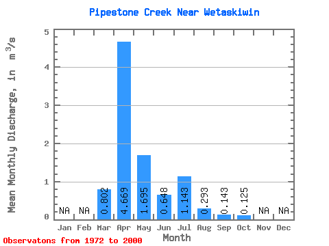
| Statistic | Jan | Feb | Mar | Apr | May | Jun | Jul | Aug | Sep | Oct | Nov | Dec | Annual |
|---|---|---|---|---|---|---|---|---|---|---|---|---|---|
| Mean | 0.80 | 4.67 | 1.69 | 0.65 | 1.14 | 0.29 | 0.14 | 0.12 | |||||
| Standard Deviation | 1.30 | 6.41 | 2.79 | 0.72 | 1.57 | 0.42 | 0.24 | 0.18 | |||||
| Min | 0.01 | 0.05 | 0.05 | 0.03 | 0.01 | 0.00 | 0.00 | 0.01 | |||||
| Max | 4.61 | 27.30 | 12.00 | 2.44 | 4.09 | 1.74 | 0.72 | 0.53 | |||||
| Coefficient of Variation | 1.63 | 1.37 | 1.65 | 1.11 | 1.38 | 1.43 | 1.68 | 1.44 |
 Return to R-Arctic Net Home Page