|
|
|||||||||||||||||
| Point ID: 531 | Downloads | Plots | Site Data | Code: 05FA012 |
|
|
|||||||||||||||||
| Download | |
|---|---|
| Site Descriptor Information | Site Time Series Data |
| Link to all available data | |
| View: | Time Series | All |
| Units: | m3/s |
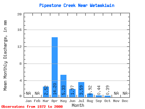
| Statistic | Jan | Feb | Mar | Apr | May | Jun | Jul | Aug | Sep | Oct | Nov | Dec | Annual |
|---|---|---|---|---|---|---|---|---|---|---|---|---|---|
| Mean | 2.08 | 11.75 | 4.41 | 1.63 | 2.97 | 0.76 | 0.36 | 0.32 | |||||
| Standard Deviation | 3.39 | 16.12 | 7.27 | 1.81 | 4.08 | 1.09 | 0.60 | 0.47 | |||||
| Min | 0.02 | 0.12 | 0.13 | 0.07 | 0.01 | 0.01 | 0.01 | 0.03 | |||||
| Max | 11.99 | 68.70 | 31.20 | 6.14 | 10.63 | 4.52 | 1.81 | 1.38 | |||||
| Coefficient of Variation | 1.63 | 1.37 | 1.65 | 1.11 | 1.38 | 1.43 | 1.68 | 1.44 |
 Return to R-Arctic Net Home Page