|
|
|||||||||||||||||
| Point ID: 5301 | Downloads | Plots | Site Data | Code: 05HD036 |
|
|
|||||||||||||||||
| Download | |
|---|---|
| Site Descriptor Information | Site Time Series Data |
| Link to all available data | |
| View: | Time Series | All |
| Units: | mm |
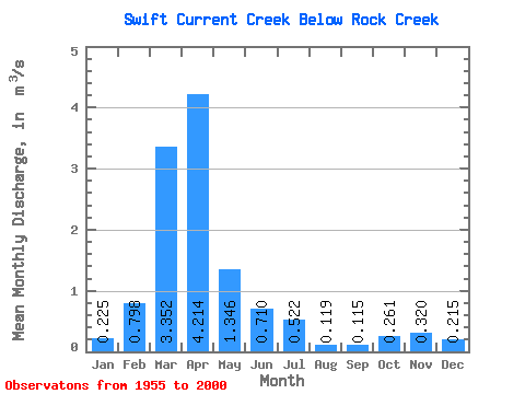
| Statistic | Jan | Feb | Mar | Apr | May | Jun | Jul | Aug | Sep | Oct | Nov | Dec | Annual |
|---|---|---|---|---|---|---|---|---|---|---|---|---|---|
| Mean | 0.23 | 0.80 | 3.35 | 4.21 | 1.35 | 0.71 | 0.52 | 0.12 | 0.12 | 0.26 | 0.32 | 0.21 | 0.88 |
| Standard Deviation | 0.24 | 0.89 | 2.61 | 4.51 | 1.25 | 0.70 | 0.78 | 0.18 | 0.18 | 0.17 | 0.13 | 0.12 | 0.46 |
| Min | 0.03 | 0.05 | 0.17 | 0.59 | 0.24 | 0.08 | 0.00 | 0.00 | 0.00 | 0.03 | 0.16 | 0.11 | 0.27 |
| Max | 1.07 | 3.40 | 10.80 | 20.00 | 7.16 | 3.73 | 4.03 | 0.74 | 0.94 | 0.78 | 0.59 | 0.66 | 1.84 |
| Coefficient of Variation | 1.05 | 1.11 | 0.78 | 1.07 | 0.93 | 0.98 | 1.50 | 1.50 | 1.54 | 0.65 | 0.39 | 0.54 | 0.52 |
 Return to R-Arctic Net Home Page