|
|
|||||||||||||||||
| Point ID: 5301 | Downloads | Plots | Site Data | Code: 05HD036 |
|
|
|||||||||||||||||
| Download | |
|---|---|
| Site Descriptor Information | Site Time Series Data |
| Link to all available data | |
| View: | Time Series | All |
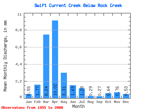
| Units: | m3/s |
| Statistic | Jan | Feb | Mar | Apr | May | Jun | Jul | Aug | Sep | Oct | Nov | Dec | Annual |
|---|---|---|---|---|---|---|---|---|---|---|---|---|---|
| Mean | 0.42 | 1.36 | 6.28 | 7.64 | 2.52 | 1.29 | 0.98 | 0.22 | 0.21 | 0.49 | 0.58 | 0.40 | 19.43 |
| Standard Deviation | 0.44 | 1.51 | 4.89 | 8.18 | 2.35 | 1.27 | 1.46 | 0.33 | 0.32 | 0.32 | 0.23 | 0.22 | 10.11 |
| Min | 0.05 | 0.09 | 0.32 | 1.08 | 0.45 | 0.15 | 0.00 | 0.00 | 0.00 | 0.06 | 0.28 | 0.20 | 5.84 |
| Max | 2.00 | 5.80 | 20.23 | 36.25 | 13.41 | 6.76 | 7.55 | 1.39 | 1.70 | 1.46 | 1.06 | 1.24 | 40.70 |
| Coefficient of Variation | 1.05 | 1.11 | 0.78 | 1.07 | 0.93 | 0.98 | 1.50 | 1.50 | 1.54 | 0.65 | 0.39 | 0.54 | 0.52 |
 Return to R-Arctic Net Home Page