|
|
|||||||||||||||||
| Point ID: 5290 | Downloads | Plots | Site Data | Code: 05HD007 |
|
|
|||||||||||||||||
| Download | |
|---|---|
| Site Descriptor Information | Site Time Series Data |
| Link to all available data | |
| View: | Time Series | All |
| Units: | mm |
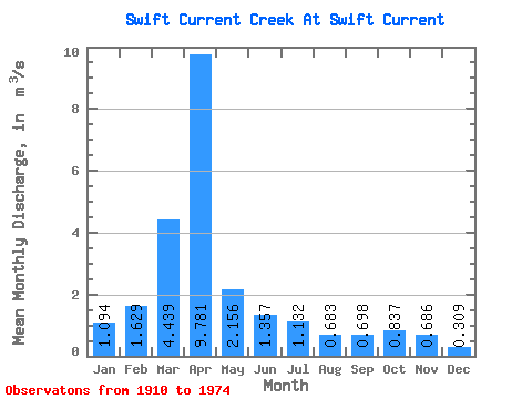
| Statistic | Jan | Feb | Mar | Apr | May | Jun | Jul | Aug | Sep | Oct | Nov | Dec | Annual |
|---|---|---|---|---|---|---|---|---|---|---|---|---|---|
| Mean | 1.09 | 1.63 | 4.44 | 9.78 | 2.16 | 1.36 | 1.13 | 0.68 | 0.70 | 0.84 | 0.69 | 0.31 | 2.28 |
| Standard Deviation | 2.24 | 2.52 | 5.03 | 12.28 | 2.58 | 1.25 | 1.49 | 0.56 | 0.57 | 1.02 | 0.24 | 0.17 | 0.90 |
| Min | 0.05 | 0.01 | 0.43 | 0.55 | 0.25 | 0.27 | 0.04 | 0.00 | 0.00 | 0.00 | 0.41 | 0.15 | 1.12 |
| Max | 5.65 | 6.53 | 19.40 | 64.40 | 10.80 | 5.73 | 9.82 | 2.54 | 2.58 | 6.99 | 1.03 | 0.62 | 3.62 |
| Coefficient of Variation | 2.04 | 1.55 | 1.13 | 1.26 | 1.20 | 0.92 | 1.32 | 0.83 | 0.82 | 1.22 | 0.35 | 0.55 | 0.40 |
 Return to R-Arctic Net Home Page