|
|
|||||||||||||||||
| Point ID: 5290 | Downloads | Plots | Site Data | Code: 05HD007 |
|
|
|||||||||||||||||
| Download | |
|---|---|
| Site Descriptor Information | Site Time Series Data |
| Link to all available data | |
| View: | Time Series | All |
| Units: | m3/s |
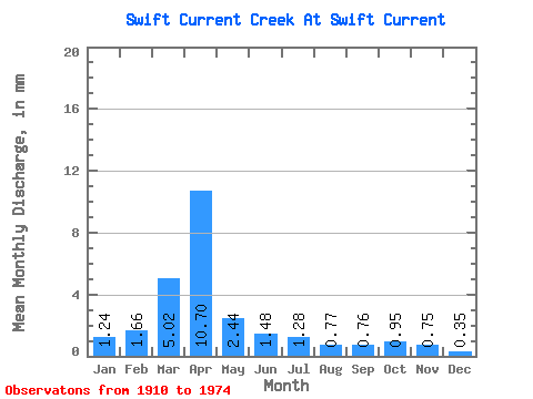
| Statistic | Jan | Feb | Mar | Apr | May | Jun | Jul | Aug | Sep | Oct | Nov | Dec | Annual |
|---|---|---|---|---|---|---|---|---|---|---|---|---|---|
| Mean | 0.89 | 1.21 | 3.62 | 7.73 | 1.76 | 1.07 | 0.92 | 0.56 | 0.55 | 0.68 | 0.54 | 0.25 | 21.93 |
| Standard Deviation | 1.83 | 1.88 | 4.11 | 9.71 | 2.11 | 0.99 | 1.22 | 0.46 | 0.45 | 0.83 | 0.19 | 0.14 | 8.66 |
| Min | 0.04 | 0.01 | 0.35 | 0.43 | 0.20 | 0.21 | 0.03 | 0.00 | 0.00 | 0.00 | 0.33 | 0.12 | 10.81 |
| Max | 4.61 | 4.86 | 15.84 | 50.89 | 8.82 | 4.53 | 8.02 | 2.07 | 2.04 | 5.71 | 0.81 | 0.50 | 34.82 |
| Coefficient of Variation | 2.04 | 1.55 | 1.13 | 1.26 | 1.20 | 0.92 | 1.32 | 0.83 | 0.82 | 1.22 | 0.35 | 0.55 | 0.40 |
 Return to R-Arctic Net Home Page