|
|
|||||||||||||||||
| Point ID: 5275 | Downloads | Plots | Site Data | Code: 05HA072 |
|
|
|||||||||||||||||
| Download | |
|---|---|
| Site Descriptor Information | Site Time Series Data |
| Link to all available data | |
| View: | Time Series | All |
| Units: | mm |
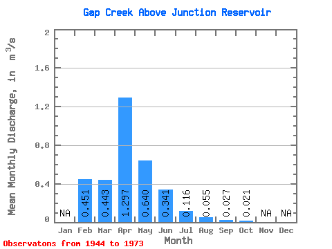
| Statistic | Jan | Feb | Mar | Apr | May | Jun | Jul | Aug | Sep | Oct | Nov | Dec | Annual |
|---|---|---|---|---|---|---|---|---|---|---|---|---|---|
| Mean | 0.45 | 0.44 | 1.30 | 0.64 | 0.34 | 0.12 | 0.06 | 0.03 | 0.02 | ||||
| Standard Deviation | 0.52 | 0.73 | 3.21 | 1.54 | 0.88 | 0.21 | 0.07 | 0.04 | 0.03 | ||||
| Min | 0.08 | 0.00 | 0.01 | 0.00 | 0.00 | 0.00 | 0.00 | 0.00 | 0.00 | ||||
| Max | 0.82 | 3.92 | 15.90 | 8.08 | 4.75 | 0.92 | 0.25 | 0.16 | 0.14 | ||||
| Coefficient of Variation | 1.15 | 1.66 | 2.48 | 2.40 | 2.57 | 1.80 | 1.31 | 1.63 | 1.43 |
 Return to R-Arctic Net Home Page