|
|
|||||||||||||||||
| Point ID: 5275 | Downloads | Plots | Site Data | Code: 05HA072 |
|
|
|||||||||||||||||
| Download | |
|---|---|
| Site Descriptor Information | Site Time Series Data |
| Link to all available data | |
| View: | Time Series | All |
| Units: | m3/s |
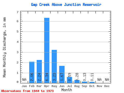
| Statistic | Jan | Feb | Mar | Apr | May | Jun | Jul | Aug | Sep | Oct | Nov | Dec | Annual |
|---|---|---|---|---|---|---|---|---|---|---|---|---|---|
| Mean | 1.96 | 2.11 | 5.98 | 3.05 | 1.57 | 0.55 | 0.26 | 0.12 | 0.10 | ||||
| Standard Deviation | 2.26 | 3.50 | 14.82 | 7.31 | 4.04 | 0.99 | 0.35 | 0.20 | 0.14 | ||||
| Min | 0.36 | 0.00 | 0.02 | 0.02 | 0.01 | 0.00 | 0.00 | 0.00 | 0.00 | ||||
| Max | 3.56 | 18.68 | 73.33 | 38.50 | 21.91 | 4.40 | 1.20 | 0.75 | 0.68 | ||||
| Coefficient of Variation | 1.15 | 1.66 | 2.48 | 2.40 | 2.57 | 1.80 | 1.31 | 1.63 | 1.43 |
 Return to R-Arctic Net Home Page