|
|
|||||||||||||||||
| Point ID: 526 | Downloads | Plots | Site Data | Code: 05FA002 |
|
|
|||||||||||||||||
| Download | |
|---|---|
| Site Descriptor Information | Site Time Series Data |
| Link to all available data | |
| View: | Time Series | All |
| Units: | mm |
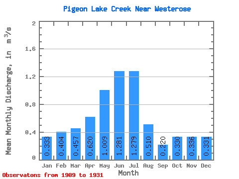
| Statistic | Jan | Feb | Mar | Apr | May | Jun | Jul | Aug | Sep | Oct | Nov | Dec | Annual |
|---|---|---|---|---|---|---|---|---|---|---|---|---|---|
| Mean | 0.33 | 0.40 | 0.46 | 0.62 | 1.01 | 1.28 | 1.28 | 0.51 | 0.22 | 0.33 | 0.34 | 0.33 | 0.50 |
| Standard Deviation | 0.43 | 0.60 | 0.61 | 0.53 | 0.76 | 0.89 | 1.15 | 0.69 | 0.26 | 0.40 | 0.41 | 0.42 | 0.42 |
| Min | 0.00 | 0.00 | 0.00 | 0.00 | 0.01 | 0.00 | 0.02 | 0.04 | 0.01 | 0.00 | 0.00 | 0.00 | 0.01 |
| Max | 1.11 | 1.58 | 1.66 | 1.53 | 2.35 | 2.84 | 2.87 | 2.15 | 0.89 | 1.09 | 0.92 | 1.02 | 1.00 |
| Coefficient of Variation | 1.29 | 1.48 | 1.33 | 0.86 | 0.75 | 0.70 | 0.90 | 1.36 | 1.18 | 1.21 | 1.21 | 1.28 | 0.84 |
 Return to R-Arctic Net Home Page