|
|
|||||||||||||||||
| Point ID: 526 | Downloads | Plots | Site Data | Code: 05FA002 |
|
|
|||||||||||||||||
| Download | |
|---|---|
| Site Descriptor Information | Site Time Series Data |
| Link to all available data | |
| View: | Time Series | All |
| Units: | m3/s |
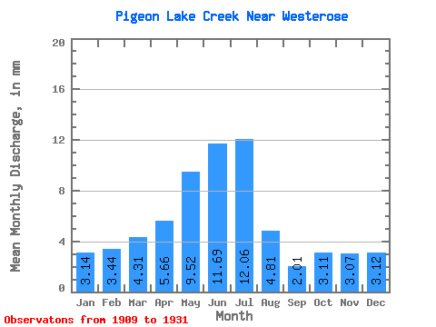
| Statistic | Jan | Feb | Mar | Apr | May | Jun | Jul | Aug | Sep | Oct | Nov | Dec | Annual |
|---|---|---|---|---|---|---|---|---|---|---|---|---|---|
| Mean | 3.14 | 3.47 | 4.30 | 5.66 | 9.51 | 11.69 | 12.06 | 4.80 | 2.01 | 3.11 | 3.06 | 3.12 | 55.46 |
| Standard Deviation | 4.06 | 5.13 | 5.72 | 4.86 | 7.13 | 8.15 | 10.82 | 6.54 | 2.38 | 3.75 | 3.69 | 4.01 | 46.46 |
| Min | 0.00 | 0.00 | 0.00 | 0.00 | 0.05 | 0.01 | 0.16 | 0.39 | 0.09 | 0.00 | 0.00 | 0.00 | 0.73 |
| Max | 10.47 | 13.57 | 15.65 | 13.96 | 22.16 | 25.92 | 27.06 | 20.27 | 8.11 | 10.28 | 8.43 | 9.62 | 111.54 |
| Coefficient of Variation | 1.29 | 1.48 | 1.33 | 0.86 | 0.75 | 0.70 | 0.90 | 1.36 | 1.18 | 1.21 | 1.21 | 1.28 | 0.84 |
 Return to R-Arctic Net Home Page