|
|
|||||||||||||||||
| Point ID: 5231 | Downloads | Plots | Site Data | Code: 05HA005 |
|
|
|||||||||||||||||
| Download | |
|---|---|
| Site Descriptor Information | Site Time Series Data |
| Link to all available data | |
| View: | Time Series | All |
| Units: | mm |
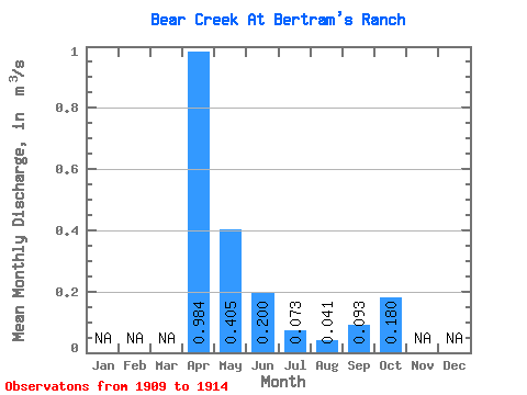
| Statistic | Jan | Feb | Mar | Apr | May | Jun | Jul | Aug | Sep | Oct | Nov | Dec | Annual |
|---|---|---|---|---|---|---|---|---|---|---|---|---|---|
| Mean | 0.98 | 0.41 | 0.20 | 0.07 | 0.04 | 0.09 | 0.18 | ||||||
| Standard Deviation | 0.85 | 0.29 | 0.17 | 0.07 | 0.05 | 0.07 | 0.03 | ||||||
| Min | 0.25 | 0.12 | 0.07 | 0.00 | 0.00 | 0.01 | 0.15 | ||||||
| Max | 2.21 | 0.88 | 0.49 | 0.17 | 0.12 | 0.17 | 0.23 | ||||||
| Coefficient of Variation | 0.87 | 0.71 | 0.85 | 0.89 | 1.15 | 0.71 | 0.14 |
 Return to R-Arctic Net Home Page