|
|
|||||||||||||||||
| Point ID: 5231 | Downloads | Plots | Site Data | Code: 05HA005 |
|
|
|||||||||||||||||
| Download | |
|---|---|
| Site Descriptor Information | Site Time Series Data |
| Link to all available data | |
| View: | Time Series | All |
| Units: | m3/s |
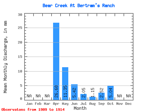
| Statistic | Jan | Feb | Mar | Apr | May | Jun | Jul | Aug | Sep | Oct | Nov | Dec | Annual |
|---|---|---|---|---|---|---|---|---|---|---|---|---|---|
| Mean | 26.67 | 11.35 | 5.42 | 2.03 | 1.16 | 2.53 | 5.05 | ||||||
| Standard Deviation | 23.16 | 8.08 | 4.60 | 1.82 | 1.33 | 1.81 | 0.69 | ||||||
| Min | 6.70 | 3.47 | 1.95 | 0.06 | 0.00 | 0.33 | 4.29 | ||||||
| Max | 59.93 | 24.71 | 13.39 | 4.82 | 3.28 | 4.55 | 6.30 | ||||||
| Coefficient of Variation | 0.87 | 0.71 | 0.85 | 0.89 | 1.15 | 0.71 | 0.14 |
 Return to R-Arctic Net Home Page