|
|
|||||||||||||||||
| Point ID: 5230 | Downloads | Plots | Site Data | Code: 05HA004 |
|
|
|||||||||||||||||
| Download | |
|---|---|
| Site Descriptor Information | Site Time Series Data |
| Link to all available data | |
| View: | Time Series | All |
| Units: | mm |
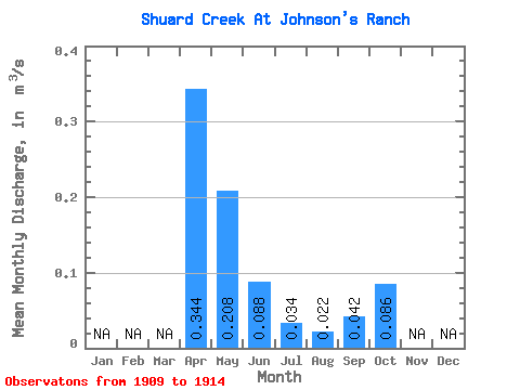
| Statistic | Jan | Feb | Mar | Apr | May | Jun | Jul | Aug | Sep | Oct | Nov | Dec | Annual |
|---|---|---|---|---|---|---|---|---|---|---|---|---|---|
| Mean | 0.34 | 0.21 | 0.09 | 0.03 | 0.02 | 0.04 | 0.09 | ||||||
| Standard Deviation | 0.16 | 0.12 | 0.05 | 0.02 | 0.02 | 0.02 | 0.03 | ||||||
| Min | 0.17 | 0.11 | 0.05 | 0.01 | 0.00 | 0.01 | 0.07 | ||||||
| Max | 0.50 | 0.40 | 0.17 | 0.06 | 0.04 | 0.07 | 0.13 | ||||||
| Coefficient of Variation | 0.47 | 0.56 | 0.57 | 0.63 | 0.73 | 0.52 | 0.32 |
 Return to R-Arctic Net Home Page