|
|
|||||||||||||||||
| Point ID: 5230 | Downloads | Plots | Site Data | Code: 05HA004 |
|
|
|||||||||||||||||
| Download | |
|---|---|
| Site Descriptor Information | Site Time Series Data |
| Link to all available data | |
| View: | Time Series | All |
| Units: | m3/s |
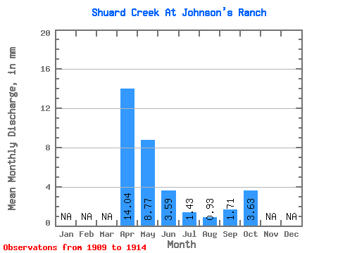
| Statistic | Jan | Feb | Mar | Apr | May | Jun | Jul | Aug | Sep | Oct | Nov | Dec | Annual |
|---|---|---|---|---|---|---|---|---|---|---|---|---|---|
| Mean | 14.03 | 8.76 | 3.60 | 1.45 | 0.94 | 1.71 | 3.64 | ||||||
| Standard Deviation | 6.67 | 4.92 | 2.05 | 0.91 | 0.68 | 0.88 | 1.16 | ||||||
| Min | 7.02 | 4.68 | 2.16 | 0.46 | 0.08 | 0.49 | 2.78 | ||||||
| Max | 20.29 | 16.79 | 7.14 | 2.49 | 1.73 | 2.82 | 5.65 | ||||||
| Coefficient of Variation | 0.47 | 0.56 | 0.57 | 0.63 | 0.73 | 0.52 | 0.32 |
 Return to R-Arctic Net Home Page