|
|
|||||||||||||||||
| Point ID: 5229 | Downloads | Plots | Site Data | Code: 05HA003 |
|
|
|||||||||||||||||
| Download | |
|---|---|
| Site Descriptor Information | Site Time Series Data |
| Link to all available data | |
| View: | Time Series | All |
| Units: | mm |
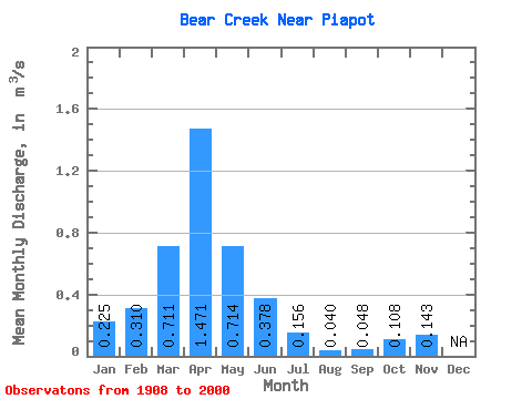
| Statistic | Jan | Feb | Mar | Apr | May | Jun | Jul | Aug | Sep | Oct | Nov | Dec | Annual |
|---|---|---|---|---|---|---|---|---|---|---|---|---|---|
| Mean | 0.23 | 0.31 | 0.71 | 1.47 | 0.71 | 0.38 | 0.16 | 0.04 | 0.05 | 0.11 | 0.14 | ||
| Standard Deviation | 0.19 | 0.29 | 0.60 | 1.31 | 0.66 | 0.38 | 0.21 | 0.05 | 0.07 | 0.12 | |||
| Min | 0.09 | 0.07 | 0.01 | 0.12 | 0.07 | 0.01 | 0.00 | 0.00 | 0.00 | 0.00 | 0.14 | ||
| Max | 0.36 | 1.05 | 2.44 | 5.11 | 3.18 | 2.41 | 1.16 | 0.20 | 0.30 | 0.49 | 0.14 | ||
| Coefficient of Variation | 0.84 | 0.94 | 0.84 | 0.89 | 0.93 | 1.01 | 1.33 | 1.31 | 1.53 | 1.07 |
 Return to R-Arctic Net Home Page