|
|
|||||||||||||||||
| Point ID: 5229 | Downloads | Plots | Site Data | Code: 05HA003 |
|
|
|||||||||||||||||
| Download | |
|---|---|
| Site Descriptor Information | Site Time Series Data |
| Link to all available data | |
| View: | Time Series | All |
| Units: | m3/s |
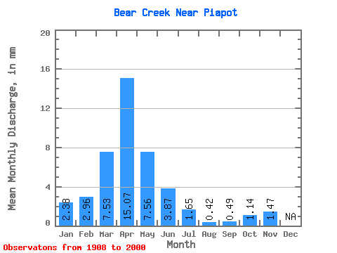
| Statistic | Jan | Feb | Mar | Apr | May | Jun | Jul | Aug | Sep | Oct | Nov | Dec | Annual |
|---|---|---|---|---|---|---|---|---|---|---|---|---|---|
| Mean | 2.38 | 2.98 | 7.53 | 15.07 | 7.55 | 3.87 | 1.66 | 0.42 | 0.49 | 1.15 | 1.47 | ||
| Standard Deviation | 1.99 | 2.80 | 6.33 | 13.46 | 7.03 | 3.92 | 2.20 | 0.55 | 0.76 | 1.23 | |||
| Min | 0.97 | 0.65 | 0.07 | 1.21 | 0.70 | 0.05 | 0.01 | 0.00 | 0.00 | 0.00 | 1.47 | ||
| Max | 3.79 | 10.13 | 25.83 | 52.35 | 33.66 | 24.69 | 12.28 | 2.15 | 3.05 | 5.14 | 1.47 | ||
| Coefficient of Variation | 0.84 | 0.94 | 0.84 | 0.89 | 0.93 | 1.01 | 1.33 | 1.31 | 1.53 | 1.07 |
 Return to R-Arctic Net Home Page