|
|
|||||||||||||||||
| Point ID: 5223 | Downloads | Plots | Site Data | Code: 05GG003 |
|
|
|||||||||||||||||
| Download | |
|---|---|
| Site Descriptor Information | Site Time Series Data |
| Link to all available data | |
| View: | Time Series | All |
| Units: | mm |
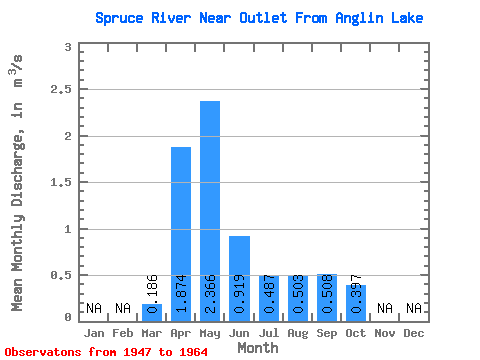
| Statistic | Jan | Feb | Mar | Apr | May | Jun | Jul | Aug | Sep | Oct | Nov | Dec | Annual |
|---|---|---|---|---|---|---|---|---|---|---|---|---|---|
| Mean | 0.19 | 1.87 | 2.37 | 0.92 | 0.49 | 0.50 | 0.51 | 0.40 | |||||
| Standard Deviation | 0.22 | 1.63 | 3.22 | 1.19 | 0.57 | 1.22 | 1.04 | 0.41 | |||||
| Min | 0.00 | 0.15 | 0.08 | 0.07 | 0.03 | 0.01 | 0.03 | 0.03 | |||||
| Max | 0.57 | 6.17 | 12.00 | 3.24 | 2.01 | 4.73 | 4.02 | 1.50 | |||||
| Coefficient of Variation | 1.18 | 0.87 | 1.36 | 1.29 | 1.18 | 2.42 | 2.05 | 1.04 |
 Return to R-Arctic Net Home Page