|
|
|||||||||||||||||
| Point ID: 5223 | Downloads | Plots | Site Data | Code: 05GG003 |
|
|
|||||||||||||||||
| Download | |
|---|---|
| Site Descriptor Information | Site Time Series Data |
| Link to all available data | |
| View: | Time Series | All |
| Units: | m3/s |
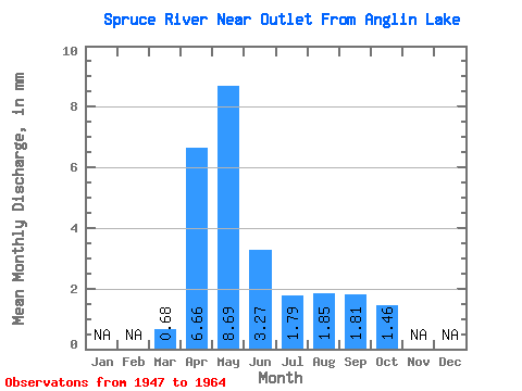
| Statistic | Jan | Feb | Mar | Apr | May | Jun | Jul | Aug | Sep | Oct | Nov | Dec | Annual |
|---|---|---|---|---|---|---|---|---|---|---|---|---|---|
| Mean | 0.63 | 6.13 | 8.00 | 3.01 | 1.65 | 1.70 | 1.66 | 1.34 | |||||
| Standard Deviation | 0.74 | 5.35 | 10.88 | 3.88 | 1.94 | 4.11 | 3.42 | 1.40 | |||||
| Min | 0.01 | 0.51 | 0.27 | 0.22 | 0.10 | 0.02 | 0.09 | 0.10 | |||||
| Max | 1.92 | 20.19 | 40.58 | 10.60 | 6.80 | 15.99 | 13.16 | 5.07 | |||||
| Coefficient of Variation | 1.18 | 0.87 | 1.36 | 1.29 | 1.18 | 2.42 | 2.05 | 1.04 |
 Return to R-Arctic Net Home Page