|
|
|||||||||||||||||
| Point ID: 5204 | Downloads | Plots | Site Data | Other Close Sites | Code: 05FF001 |
|
|
|||||||||||||||||
| Download | |
|---|---|
| Site Descriptor Information | Site Time Series Data |
| Link to all available data | |
| View: | Time Series | All |
| Units: | mm |
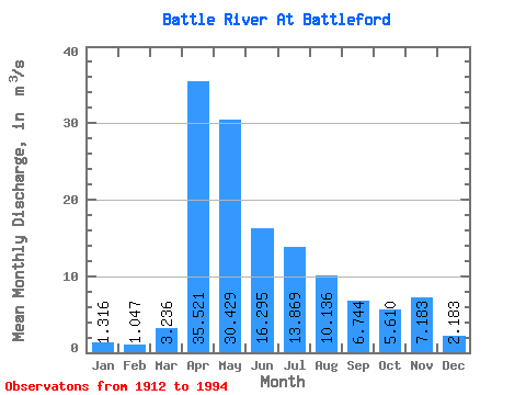
| Statistic | Jan | Feb | Mar | Apr | May | Jun | Jul | Aug | Sep | Oct | Nov | Dec | Annual |
|---|---|---|---|---|---|---|---|---|---|---|---|---|---|
| Mean | 1.32 | 1.05 | 3.24 | 35.52 | 30.43 | 16.30 | 13.87 | 10.14 | 6.74 | 5.61 | 7.18 | 2.18 | 16.96 |
| Standard Deviation | 1.35 | 1.06 | 5.31 | 25.64 | 41.94 | 16.91 | 14.60 | 12.03 | 9.07 | 6.69 | 6.06 | 1.57 | 5.96 |
| Min | 0.19 | 0.00 | 0.00 | 4.98 | 3.95 | 2.23 | 1.96 | 1.19 | 0.86 | 0.65 | 1.49 | 0.61 | 5.62 |
| Max | 4.01 | 3.23 | 30.30 | 97.80 | 280.00 | 87.50 | 56.50 | 50.70 | 55.00 | 42.40 | 20.10 | 4.65 | 22.53 |
| Coefficient of Variation | 1.02 | 1.01 | 1.64 | 0.72 | 1.38 | 1.04 | 1.05 | 1.19 | 1.35 | 1.19 | 0.84 | 0.72 | 0.35 |
| Other Close Sites | ||||||
|---|---|---|---|---|---|---|
| PointID | Latitude | Longitude | Drainage Area | Source | Name | |
| 5196 | "NORTH SASKATCHEWAN RIVER NEAR NORTH BATTLEFORD" | 52.75 | 1278496 | Hydat | ||
 Return to R-Arctic Net Home Page