|
|
|||||||||||||||||
| Point ID: 5204 | Downloads | Plots | Site Data | Other Close Sites | Code: 05FF001 |
|
|
|||||||||||||||||
| Download | |
|---|---|
| Site Descriptor Information | Site Time Series Data |
| Link to all available data | |
| View: | Time Series | All |
| Units: | m3/s |
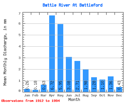
| Statistic | Jan | Feb | Mar | Apr | May | Jun | Jul | Aug | Sep | Oct | Nov | Dec | Annual |
|---|---|---|---|---|---|---|---|---|---|---|---|---|---|
| Mean | 0.12 | 0.09 | 0.29 | 3.10 | 2.74 | 1.42 | 1.25 | 0.91 | 0.59 | 0.51 | 0.63 | 0.20 | 18.02 |
| Standard Deviation | 0.12 | 0.09 | 0.48 | 2.24 | 3.78 | 1.48 | 1.32 | 1.08 | 0.79 | 0.60 | 0.53 | 0.14 | 6.34 |
| Min | 0.02 | 0.00 | 0.00 | 0.43 | 0.36 | 0.20 | 0.18 | 0.11 | 0.07 | 0.06 | 0.13 | 0.06 | 5.97 |
| Max | 0.36 | 0.27 | 2.73 | 8.54 | 25.25 | 7.64 | 5.09 | 4.57 | 4.80 | 3.82 | 1.75 | 0.42 | 23.94 |
| Coefficient of Variation | 1.02 | 1.01 | 1.64 | 0.72 | 1.38 | 1.04 | 1.05 | 1.19 | 1.35 | 1.19 | 0.84 | 0.72 | 0.35 |
| Other Close Sites | ||||||
|---|---|---|---|---|---|---|
| PointID | Latitude | Longitude | Drainage Area | Source | Name | |
| 5196 | "NORTH SASKATCHEWAN RIVER NEAR NORTH BATTLEFORD" | 52.75 | 1278496 | Hydat | ||
 Return to R-Arctic Net Home Page