|
|
|||||||||||||||||
| Point ID: 5193 | Downloads | Plots | Site Data | Code: 05EF004 |
|
|
|||||||||||||||||
| Download | |
|---|---|
| Site Descriptor Information | Site Time Series Data |
| Link to all available data | |
| View: | Time Series | All |
| Units: | mm |
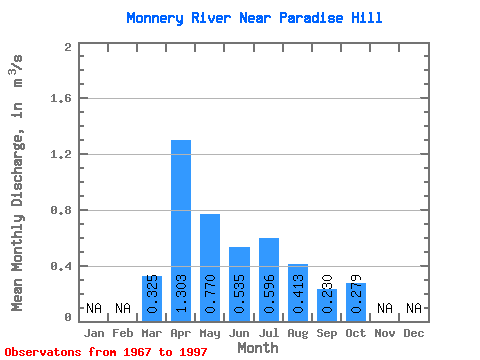
| Statistic | Jan | Feb | Mar | Apr | May | Jun | Jul | Aug | Sep | Oct | Nov | Dec | Annual |
|---|---|---|---|---|---|---|---|---|---|---|---|---|---|
| Mean | 0.33 | 1.30 | 0.77 | 0.54 | 0.60 | 0.41 | 0.23 | 0.28 | |||||
| Standard Deviation | 0.28 | 0.71 | 0.57 | 0.60 | 0.72 | 0.79 | 0.16 | 0.12 | |||||
| Min | 0.03 | 0.34 | 0.24 | 0.13 | 0.01 | 0.01 | 0.02 | 0.02 | |||||
| Max | 1.73 | 3.67 | 2.92 | 3.27 | 2.66 | 4.31 | 0.65 | 0.52 | |||||
| Coefficient of Variation | 0.87 | 0.54 | 0.74 | 1.11 | 1.22 | 1.91 | 0.71 | 0.41 |
 Return to R-Arctic Net Home Page