|
|
|||||||||||||||||
| Point ID: 5193 | Downloads | Plots | Site Data | Code: 05EF004 |
|
|
|||||||||||||||||
| Download | |
|---|---|
| Site Descriptor Information | Site Time Series Data |
| Link to all available data | |
| View: | Time Series | All |
| Units: | m3/s |
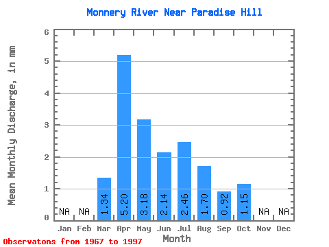
| Statistic | Jan | Feb | Mar | Apr | May | Jun | Jul | Aug | Sep | Oct | Nov | Dec | Annual |
|---|---|---|---|---|---|---|---|---|---|---|---|---|---|
| Mean | 0.99 | 3.86 | 2.36 | 1.58 | 1.82 | 1.26 | 0.68 | 0.85 | |||||
| Standard Deviation | 0.86 | 2.10 | 1.75 | 1.77 | 2.21 | 2.41 | 0.48 | 0.35 | |||||
| Min | 0.10 | 1.02 | 0.72 | 0.39 | 0.03 | 0.02 | 0.05 | 0.07 | |||||
| Max | 5.29 | 10.87 | 8.94 | 9.69 | 8.14 | 13.19 | 1.91 | 1.59 | |||||
| Coefficient of Variation | 0.87 | 0.54 | 0.74 | 1.11 | 1.22 | 1.91 | 0.71 | 0.41 |
 Return to R-Arctic Net Home Page