|
|
|||||||||||||||||
| Point ID: 5191 | Downloads | Plots | Site Data | Code: 05AH050 |
|
|
|||||||||||||||||
| Download | |
|---|---|
| Site Descriptor Information | Site Time Series Data |
| Link to all available data | |
| View: | Time Series | All |
| Units: | mm |
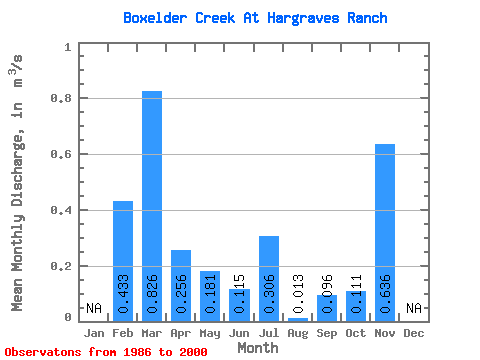
| Statistic | Jan | Feb | Mar | Apr | May | Jun | Jul | Aug | Sep | Oct | Nov | Dec | Annual |
|---|---|---|---|---|---|---|---|---|---|---|---|---|---|
| Mean | 0.43 | 0.83 | 0.26 | 0.18 | 0.12 | 0.31 | 0.01 | 0.10 | 0.11 | 0.64 | |||
| Standard Deviation | 1.24 | 1.55 | 0.40 | 0.31 | 0.33 | 0.83 | 0.05 | 0.28 | 0.33 | ||||
| Min | 0.00 | 0.00 | 0.00 | 0.00 | 0.00 | 0.00 | 0.00 | 0.00 | 0.00 | 0.64 | |||
| Max | 4.66 | 4.63 | 1.20 | 1.09 | 1.28 | 3.13 | 0.18 | 1.03 | 1.28 | 0.64 | |||
| Coefficient of Variation | 2.86 | 1.87 | 1.57 | 1.70 | 2.84 | 2.71 | 3.59 | 2.91 | 2.98 |
 Return to R-Arctic Net Home Page