|
|
|||||||||||||||||
| Point ID: 5191 | Downloads | Plots | Site Data | Code: 05AH050 |
|
|
|||||||||||||||||
| Download | |
|---|---|
| Site Descriptor Information | Site Time Series Data |
| Link to all available data | |
| View: | Time Series | All |
| Units: | m3/s |
| Statistic | Jan | Feb | Mar | Apr | May | Jun | Jul | Aug | Sep | Oct | Nov | Dec | Annual |
|---|---|---|---|---|---|---|---|---|---|---|---|---|---|
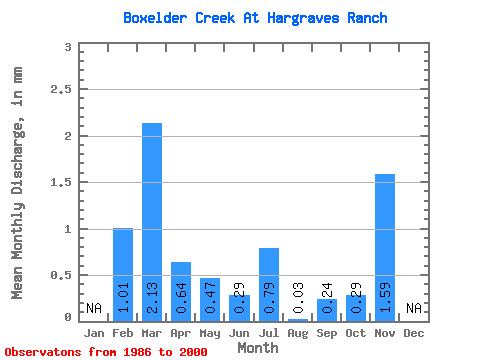
| Mean | 1.02 | 2.13 | 0.64 | 0.47 | 0.29 | 0.79 | 0.03 | 0.24 | 0.29 | 1.58 | |||
| Standard Deviation | 2.90 | 3.99 | 1.00 | 0.79 | 0.81 | 2.13 | 0.12 | 0.69 | 0.85 | ||||
| Min | 0.00 | 0.00 | 0.00 | 0.00 | 0.00 | 0.00 | 0.00 | 0.00 | 0.00 | 1.58 | |||
| Max | 10.93 | 11.92 | 2.99 | 2.81 | 3.19 | 8.06 | 0.47 | 2.57 | 3.30 | 1.58 | |||
| Coefficient of Variation | 2.86 | 1.87 | 1.57 | 1.70 | 2.84 | 2.71 | 3.59 | 2.91 | 2.98 |
 Return to R-Arctic Net Home Page