|
|
|||||||||||||||||
| Point ID: 5189 | Downloads | Plots | Site Data | Code: 04NB001 |
|
|
|||||||||||||||||
| Download | |
|---|---|
| Site Descriptor Information | Site Time Series Data |
| Link to all available data | |
| View: | Time Series | All |
| Units: | mm |
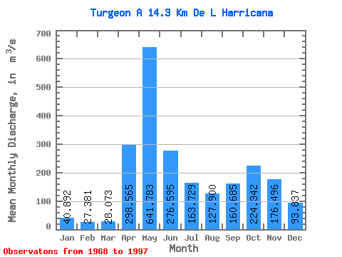
| Statistic | Jan | Feb | Mar | Apr | May | Jun | Jul | Aug | Sep | Oct | Nov | Dec | Annual |
|---|---|---|---|---|---|---|---|---|---|---|---|---|---|
| Mean | 40.89 | 27.38 | 28.07 | 298.56 | 641.78 | 276.60 | 163.73 | 127.90 | 160.69 | 224.34 | 176.50 | 93.84 | 193.86 |
| Standard Deviation | 17.18 | 11.76 | 17.84 | 188.16 | 231.08 | 170.62 | 64.88 | 68.28 | 82.94 | 86.84 | 65.54 | 49.30 | 35.16 |
| Min | 20.20 | 13.10 | 11.00 | 46.80 | 237.00 | 80.10 | 63.90 | 36.40 | 40.30 | 56.80 | 61.20 | 31.50 | 143.65 |
| Max | 101.00 | 49.70 | 81.10 | 678.00 | 1070.00 | 855.00 | 316.00 | 279.00 | 328.00 | 399.00 | 318.00 | 231.00 | 274.82 |
| Coefficient of Variation | 0.42 | 0.43 | 0.64 | 0.63 | 0.36 | 0.62 | 0.40 | 0.53 | 0.52 | 0.39 | 0.37 | 0.53 | 0.18 |
 Return to R-Arctic Net Home Page