|
|
|||||||||||||||||
| Point ID: 5189 | Downloads | Plots | Site Data | Code: 04NB001 |
|
|
|||||||||||||||||
| Download | |
|---|---|
| Site Descriptor Information | Site Time Series Data |
| Link to all available data | |
| View: | Time Series | All |
| Units: | m3/s |
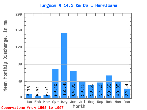
| Statistic | Jan | Feb | Mar | Apr | May | Jun | Jul | Aug | Sep | Oct | Nov | Dec | Annual |
|---|---|---|---|---|---|---|---|---|---|---|---|---|---|
| Mean | 9.78 | 5.96 | 6.71 | 69.10 | 153.46 | 64.01 | 39.15 | 30.58 | 37.19 | 53.64 | 40.85 | 22.44 | 546.28 |
| Standard Deviation | 4.11 | 2.56 | 4.26 | 43.55 | 55.25 | 39.49 | 15.51 | 16.33 | 19.20 | 20.76 | 15.17 | 11.79 | 99.07 |
| Min | 4.83 | 2.85 | 2.63 | 10.83 | 56.67 | 18.54 | 15.28 | 8.70 | 9.33 | 13.58 | 14.16 | 7.53 | 404.79 |
| Max | 24.15 | 10.83 | 19.39 | 156.91 | 255.84 | 197.87 | 75.56 | 66.71 | 75.91 | 95.40 | 73.59 | 55.23 | 774.39 |
| Coefficient of Variation | 0.42 | 0.43 | 0.64 | 0.63 | 0.36 | 0.62 | 0.40 | 0.53 | 0.52 | 0.39 | 0.37 | 0.53 | 0.18 |
 Return to R-Arctic Net Home Page