|
|
|||||||||||||||||
| Point ID: 5180 | Downloads | Plots | Site Data | Code: 03MB001 |
|
|
|||||||||||||||||
| Download | |
|---|---|
| Site Descriptor Information | Site Time Series Data |
| Link to all available data | |
| View: | Time Series | All |
| Units: | mm |
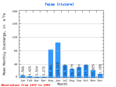
| Statistic | Jan | Feb | Mar | Apr | May | Jun | Jul | Aug | Sep | Oct | Nov | Dec | Annual |
|---|---|---|---|---|---|---|---|---|---|---|---|---|---|
| Mean | 6.57 | 4.42 | 3.50 | 3.27 | 83.46 | 104.24 | 36.89 | 26.48 | 31.50 | 37.94 | 22.82 | 11.19 | 30.73 |
| Standard Deviation | 2.08 | 1.73 | 1.55 | 1.45 | 46.31 | 37.39 | 10.53 | 15.45 | 15.15 | 14.45 | 7.80 | 3.06 | 3.96 |
| Min | 4.14 | 2.48 | 1.63 | 1.36 | 6.75 | 47.70 | 19.20 | 12.40 | 13.80 | 16.90 | 11.70 | 7.08 | 20.40 |
| Max | 11.80 | 9.47 | 7.85 | 6.92 | 180.00 | 167.00 | 59.50 | 74.00 | 76.60 | 62.40 | 49.10 | 18.70 | 36.98 |
| Coefficient of Variation | 0.32 | 0.39 | 0.44 | 0.44 | 0.56 | 0.36 | 0.28 | 0.58 | 0.48 | 0.38 | 0.34 | 0.27 | 0.13 |
 Return to R-Arctic Net Home Page