|
|
|||||||||||||||||
| Point ID: 5180 | Downloads | Plots | Site Data | Code: 03MB001 |
|
|
|||||||||||||||||
| Download | |
|---|---|
| Site Descriptor Information | Site Time Series Data |
| Link to all available data | |
| View: | Time Series | All |
| Units: | m3/s |
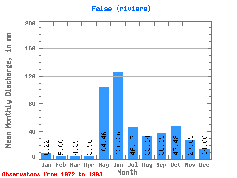
| Statistic | Jan | Feb | Mar | Apr | May | Jun | Jul | Aug | Sep | Oct | Nov | Dec | Annual |
|---|---|---|---|---|---|---|---|---|---|---|---|---|---|
| Mean | 8.22 | 5.05 | 4.38 | 3.96 | 104.44 | 126.26 | 46.16 | 33.14 | 38.15 | 47.47 | 27.65 | 14.00 | 453.14 |
| Standard Deviation | 2.61 | 1.98 | 1.94 | 1.75 | 57.96 | 45.29 | 13.18 | 19.33 | 18.35 | 18.08 | 9.45 | 3.82 | 58.40 |
| Min | 5.18 | 2.83 | 2.04 | 1.65 | 8.45 | 57.77 | 24.03 | 15.52 | 16.71 | 21.15 | 14.17 | 8.86 | 300.91 |
| Max | 14.77 | 10.80 | 9.82 | 8.38 | 225.25 | 202.27 | 74.46 | 92.60 | 92.78 | 78.09 | 59.47 | 23.40 | 545.39 |
| Coefficient of Variation | 0.32 | 0.39 | 0.44 | 0.44 | 0.56 | 0.36 | 0.28 | 0.58 | 0.48 | 0.38 | 0.34 | 0.27 | 0.13 |
 Return to R-Arctic Net Home Page