|
|
|||||||||||||||||
| Point ID: 5170 | Downloads | Plots | Site Data | Code: 03KA001 |
|
|
|||||||||||||||||
| Download | |
|---|---|
| Site Descriptor Information | Site Time Series Data |
| Link to all available data | |
| View: | Time Series | All |
| Units: | mm |
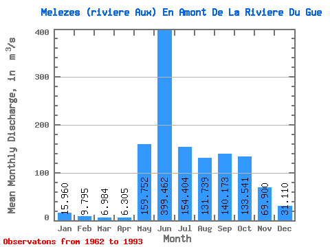
| Statistic | Jan | Feb | Mar | Apr | May | Jun | Jul | Aug | Sep | Oct | Nov | Dec | Annual |
|---|---|---|---|---|---|---|---|---|---|---|---|---|---|
| Mean | 15.96 | 9.79 | 6.98 | 6.30 | 159.75 | 399.46 | 154.40 | 131.74 | 140.17 | 133.54 | 69.90 | 31.11 | 106.65 |
| Standard Deviation | 3.82 | 2.75 | 2.32 | 2.23 | 108.01 | 118.57 | 51.48 | 81.66 | 56.51 | 32.66 | 19.11 | 7.97 | 14.17 |
| Min | 8.68 | 4.59 | 2.82 | 3.12 | 3.70 | 196.00 | 84.00 | 54.90 | 74.10 | 64.70 | 39.50 | 15.60 | 82.29 |
| Max | 22.30 | 14.80 | 11.80 | 12.10 | 351.00 | 673.00 | 263.00 | 403.00 | 308.00 | 201.00 | 113.00 | 44.50 | 135.88 |
| Coefficient of Variation | 0.24 | 0.28 | 0.33 | 0.35 | 0.68 | 0.30 | 0.33 | 0.62 | 0.40 | 0.24 | 0.27 | 0.26 | 0.13 |
 Return to R-Arctic Net Home Page