|
|
|||||||||||||||||
| Point ID: 5170 | Downloads | Plots | Site Data | Code: 03KA001 |
|
|
|||||||||||||||||
| Download | |
|---|---|
| Site Descriptor Information | Site Time Series Data |
| Link to all available data | |
| View: | Time Series | All |
| Units: | m3/s |
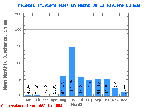
| Statistic | Jan | Feb | Mar | Apr | May | Jun | Jul | Aug | Sep | Oct | Nov | Dec | Annual |
|---|---|---|---|---|---|---|---|---|---|---|---|---|---|
| Mean | 4.84 | 2.71 | 2.12 | 1.85 | 48.45 | 117.26 | 46.83 | 39.95 | 41.15 | 40.50 | 20.52 | 9.44 | 381.17 |
| Standard Deviation | 1.16 | 0.76 | 0.70 | 0.65 | 32.76 | 34.81 | 15.61 | 24.77 | 16.59 | 9.90 | 5.61 | 2.42 | 50.66 |
| Min | 2.63 | 1.27 | 0.85 | 0.92 | 1.12 | 57.53 | 25.48 | 16.65 | 21.75 | 19.62 | 11.60 | 4.73 | 294.12 |
| Max | 6.76 | 4.09 | 3.58 | 3.55 | 106.45 | 197.56 | 79.76 | 122.22 | 90.41 | 60.96 | 33.17 | 13.50 | 485.64 |
| Coefficient of Variation | 0.24 | 0.28 | 0.33 | 0.35 | 0.68 | 0.30 | 0.33 | 0.62 | 0.40 | 0.24 | 0.27 | 0.26 | 0.13 |
 Return to R-Arctic Net Home Page