|
|
|||||||||||||||||
| Point ID: 5145 | Downloads | Plots | Site Data | Code: 03FA004 |
|
|
|||||||||||||||||
| Download | |
|---|---|
| Site Descriptor Information | Site Time Series Data |
| Link to all available data | |
| View: | Time Series | All |
| Units: | mm |
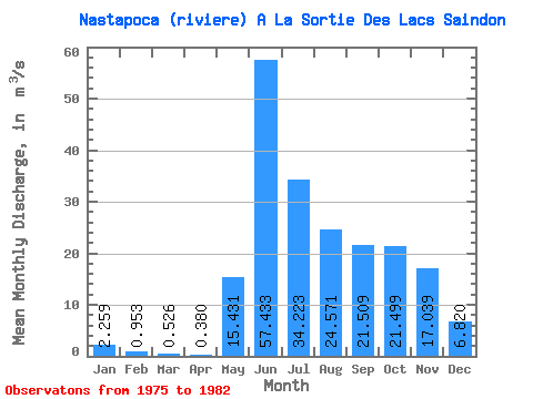
| Statistic | Jan | Feb | Mar | Apr | May | Jun | Jul | Aug | Sep | Oct | Nov | Dec | Annual |
|---|---|---|---|---|---|---|---|---|---|---|---|---|---|
| Mean | 2.26 | 0.95 | 0.53 | 0.38 | 15.43 | 57.43 | 34.22 | 24.57 | 21.51 | 21.50 | 17.04 | 6.82 | 16.58 |
| Standard Deviation | 1.01 | 0.30 | 0.13 | 0.10 | 10.59 | 26.29 | 15.47 | 15.65 | 16.52 | 15.71 | 10.54 | 4.27 | 4.54 |
| Min | 1.27 | 0.59 | 0.34 | 0.24 | 0.39 | 19.20 | 8.56 | 12.00 | 5.34 | 9.52 | 6.55 | 3.03 | 11.81 |
| Max | 4.27 | 1.52 | 0.73 | 0.55 | 29.50 | 91.60 | 50.50 | 54.80 | 53.20 | 53.70 | 38.40 | 15.80 | 24.57 |
| Coefficient of Variation | 0.45 | 0.31 | 0.24 | 0.26 | 0.69 | 0.46 | 0.45 | 0.64 | 0.77 | 0.73 | 0.62 | 0.63 | 0.27 |
 Return to R-Arctic Net Home Page