|
|
|||||||||||||||||
| Point ID: 5145 | Downloads | Plots | Site Data | Code: 03FA004 |
|
|
|||||||||||||||||
| Download | |
|---|---|
| Site Descriptor Information | Site Time Series Data |
| Link to all available data | |
| View: | Time Series | All |
| Units: | m3/s |
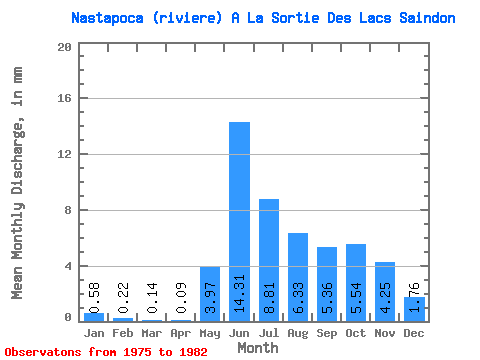
| Statistic | Jan | Feb | Mar | Apr | May | Jun | Jul | Aug | Sep | Oct | Nov | Dec | Annual |
|---|---|---|---|---|---|---|---|---|---|---|---|---|---|
| Mean | 0.58 | 0.22 | 0.14 | 0.10 | 3.97 | 14.31 | 8.81 | 6.33 | 5.36 | 5.54 | 4.25 | 1.76 | 50.32 |
| Standard Deviation | 0.26 | 0.07 | 0.03 | 0.03 | 2.73 | 6.55 | 3.98 | 4.03 | 4.12 | 4.04 | 2.63 | 1.10 | 13.79 |
| Min | 0.33 | 0.14 | 0.09 | 0.06 | 0.10 | 4.79 | 2.20 | 3.09 | 1.33 | 2.45 | 1.63 | 0.78 | 35.84 |
| Max | 1.10 | 0.36 | 0.19 | 0.14 | 7.60 | 22.83 | 13.00 | 14.11 | 13.26 | 13.83 | 9.57 | 4.07 | 74.55 |
| Coefficient of Variation | 0.45 | 0.31 | 0.24 | 0.26 | 0.69 | 0.46 | 0.45 | 0.64 | 0.77 | 0.73 | 0.62 | 0.63 | 0.27 |
 Return to R-Arctic Net Home Page