|
|
|||||||||||||||||
| Point ID: 5140 | Downloads | Plots | Site Data | Code: 03ED004 |
|
|
|||||||||||||||||
| Download | |
|---|---|
| Site Descriptor Information | Site Time Series Data |
| Link to all available data | |
| View: | Time Series | All |
| Units: | mm |
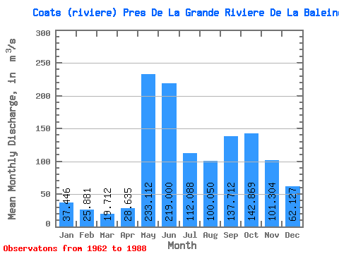
| Statistic | Jan | Feb | Mar | Apr | May | Jun | Jul | Aug | Sep | Oct | Nov | Dec | Annual |
|---|---|---|---|---|---|---|---|---|---|---|---|---|---|
| Mean | 37.45 | 25.88 | 19.71 | 28.64 | 233.11 | 219.00 | 112.09 | 100.05 | 137.71 | 142.87 | 101.30 | 62.13 | 102.00 |
| Standard Deviation | 8.01 | 4.46 | 3.74 | 18.69 | 81.46 | 83.62 | 39.01 | 39.23 | 46.23 | 47.64 | 27.21 | 15.99 | 13.69 |
| Min | 21.90 | 14.90 | 12.80 | 12.20 | 92.10 | 98.00 | 63.30 | 46.00 | 69.90 | 74.20 | 58.60 | 44.10 | 82.13 |
| Max | 57.10 | 35.30 | 27.40 | 84.40 | 459.00 | 433.00 | 226.00 | 197.00 | 227.00 | 270.00 | 182.00 | 102.00 | 129.01 |
| Coefficient of Variation | 0.21 | 0.17 | 0.19 | 0.65 | 0.35 | 0.38 | 0.35 | 0.39 | 0.34 | 0.33 | 0.27 | 0.26 | 0.13 |
 Return to R-Arctic Net Home Page